Mission Planning & Real‑Time Management
LaunchPADS™ Mission Manager
LaunchPADS™ Mission Manager
Plan, execute, and review cargo airdrop and parachute operations with confidence.
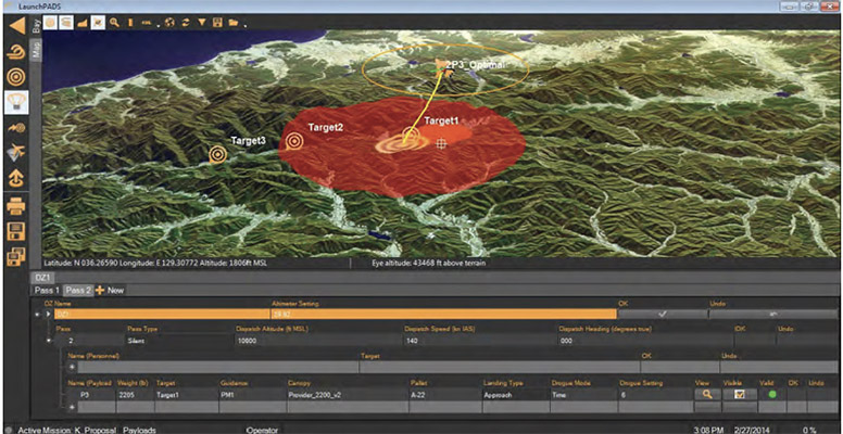
LaunchPADS™ is a mission planning and management system designed to help aircrew and operators build, monitor, and refine aerial delivery and airborne parachute missions using 2D/3D GIS terrain context. It generates concise release points and mission footprints for the operation at hand, supporting both cargo airdrop and airborne parachute activities from a single, integrated mission environment.
Whether you’re running guided cargo delivery, unguided rounds, personnel insertion, or mixed missions, LaunchPADS™ brings planning, execution support, and post‑mission review into one workflow — with integration pathways to MMIST systems including Sherpa™, SkyLink™, and Drop Sondes.
Why teams choose LaunchPADS™
- Precision planning: Build detailed deployment plans with mapping and simulation tools to reduce planning error and increase drop accuracy.
- Real‑time monitoring: Track mission status and progress live during execution.
- Automated re‑tasking: Update mission parameters as conditions change (including in‑flight CARP updates where applicable).
- Works across mission types: Supports guided and non‑guided parachutes, cargo and personnel, and single or multiple targets.
- Ruggedised deployment: Delivered on a rugged laptop interface built for demanding environments.
End‑to‑end mission planning workflow
- Release point planning: Supports gliding (ram‑air) and non‑gliding (round) parachutes for cargo, personnel, and mixed missions, including single or multiple targets using single or multiple releases.
- Cargo bay planning: Preliminary planning for load sequence and layout.
- Mission management: Supports in‑flight CARP updates (based on mission and/or wind changes), plus programming, monitoring, and re‑tasking.
- Post‑flight analysis: Log retrieval/storage (for Sherpa& SkyLink), mission replay, and visualisation.
Core capabilities (highlights)
- Fully integrated cargo & personnel aerial release planning
- Planning for guided and non‑guided parachutes
- Single or multiple targets using single or multiple release points
- Full 2D/3D GIS map overlay (imagery, scenery, and DTED)
- Mission simulation and playback
- Real‑time on‑board health status monitoring (system dependent)
- Multi‑lingual support
- Integrated cargo bay planning module
Integration options (MMIST ecosystem)
- LaunchPADS + Sherpa™: Calculate and display Launch Acceptability Region (LAR) to support release point selection while accounting for wind, terrain, airspace restrictions, and potential failure areas. Adjust aircraft run‑in heading, release point, deployment altitude, and parachute opening altitude (for programmable HALO systems) up until deployment. Wireless connection to multiple guidance units (or wired to one), with verification that uploads were correctly received.
- LaunchPADS + SkyLink™: Concurrent planning and display for cargo payloads and personnel to support effective and safe deployments on combo‑type flights.
- LaunchPADS + Drop Sondes: Real‑time wind data collection to help determine optimal release points. (Drop Sondes descend at approximately 25 m/s / 5,000 ft/min.)
- Optional GPS redistributor: Re‑broadcast GPS to Wi‑Fi enabled devices in areas where GPS struggles to penetrate (for example, inside an aircraft), shortening GPS re‑acquisition time and improving flexibility inside the cargo bay.
Hardware platform (rugged mission computer)
LaunchPADS™ is delivered as a rugged PC/laptop system with a factory‑installed GPS receiver and SSD storage designed to function at high altitudes, plus security features to prevent unauthorised access. It supports wired or wireless device connectivity and includes EMI/EMC‑shielded cabling where applicable.
Key specs (LaunchPADS Multi‑Mission Manager)
- Dimensions: 30 cm (L) × 35 cm (W) × 5.3 cm (H)
- Weight: 3.4 kg
- Battery: Li‑ion, up to 15 hours (user‑replaceable); approx. 3 hours charge time
- Power: AC adapter 100–240 V (worldwide)
- Display: 35.6 cm (14.0″) FHD 1920 × 1080 capacitive, gloved touch; anti‑reflective treatment; up to 1,200 nits
- Processor: Intel® Core™ i5‑1145G7 vPro®
- Memory / Storage: 16 GB RAM; 1 TB SSD
- Connectivity: Wi‑Fi, Bluetooth; wireless or wired device connections (802.11b/g, ~90 m range)
- Environmental: Tested to MIL‑STD‑810H (environment) and MIL‑STD‑461G (EMI/EMC)
- Ingress protection: IP66
- OS: Windows 10 Pro
What’s included
- Rugged laptop/PC with factory‑installed GPS receiver
- LaunchPADS™ mission management software (unlimited user licence)
- Power adapters
- Mission planning cables (where applicable)
Upgrade your mission planning workflow with a rugged, end‑to‑end system built for precision aerial delivery and airborne insertion. Contact J3Seven to configure LaunchPADS™ with the modules and integrations that match your aircraft, parachute systems, and operating environment.
Quick‑look feature bullets
- Mission planning + execution support + post‑flight review in one system
- CARP planning for HALO/HAHO operations; supports multi‑parachute workflows
- 2D/3D GIS overlays (imagery, scenery, DTED) with mission replay/visualisation
- Optional integrations: Sherpa™, SkyLink™, Drop Sondes, GPS redistributor
- Rugged, field‑ready laptop platform (IP66; MIL‑STD‑810H / MIL‑STD‑461G)
Frequently asked questions
Can LaunchPADS™ be used beyond MMIST guided systems?
Yes. LaunchPADS™ is integrated with MMIST precision aerial delivery systems, and can also be used for customer‑specific parachute equipment for ram‑air or round parachute operations (parachute characterisation may be required, depending on the system).
What coordinate formats does LaunchPADS™ support?
LaunchPADS™ supports numeric coordinate entry using latitude/longitude, UTM, and MGRS formats, alongside map‑based selection within the GIS overlay.
How does LaunchPADS™ connect to other devices?
It supports wired and wireless connectivity (including 802.11b/g wireless links, approximately 90 m range) to connect with compatible MMIST devices and configurations.
Does LaunchPADS™ support in‑flight updates?
Yes. LaunchPADS™ supports in‑flight CARP updates based on mission and/or environmental changes (module/configuration dependent).
Are there export or controlled‑goods considerations?
Compliance note: MMIST advises that export of its products may be subject to Canadian export controls and that licences may be required. Always confirm regulatory requirements prior to procurement, deployment, transfer, or export.